Indonesia earthquake: Huge surge in death toll

Article By: BBC News

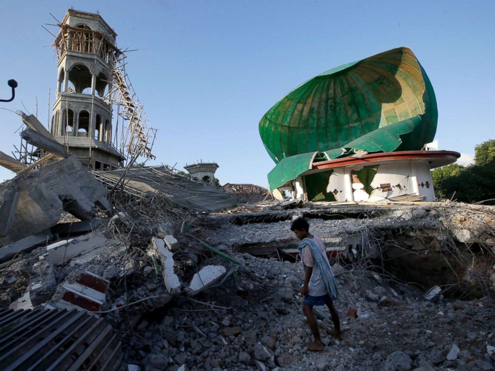
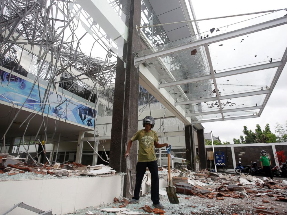
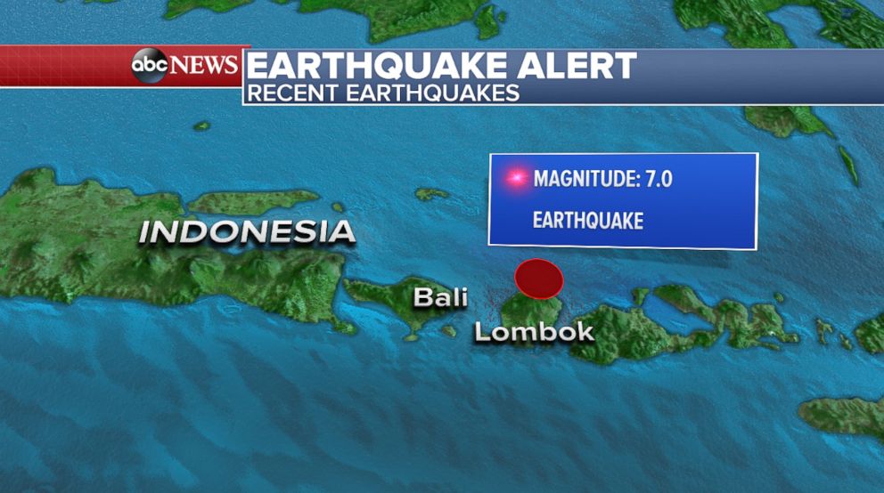
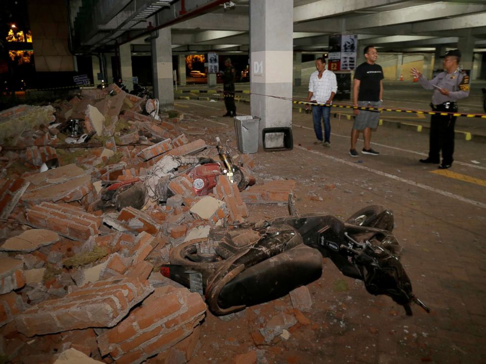
At least 832 people were killed in the devastating earthquake and tsunami that hit the Indonesian island of Sulawesi, the national disaster agency says. Many people were reported trapped in the rubble of buildings that collapsed in Friday’s 7.5-magnitude earthquake, agency spokesman Sutopo Purwo Nugroho told a news conference. The quake triggered tsunami waves as high as 6m (20ft), he added.

Vice-President Jusuf Kalla said the final death toll could be thousands.

Rescuers have been digging by hand in the search for survivors in the city of Palu.

“What we now desperately need is heavy machinery to clear the rubble. I have my staff on the ground, but it’s impossible just to rely on their strength alone to clear this,” Muhammad Syaugi, head of the national search-and-rescue agency, told AFP news agency.

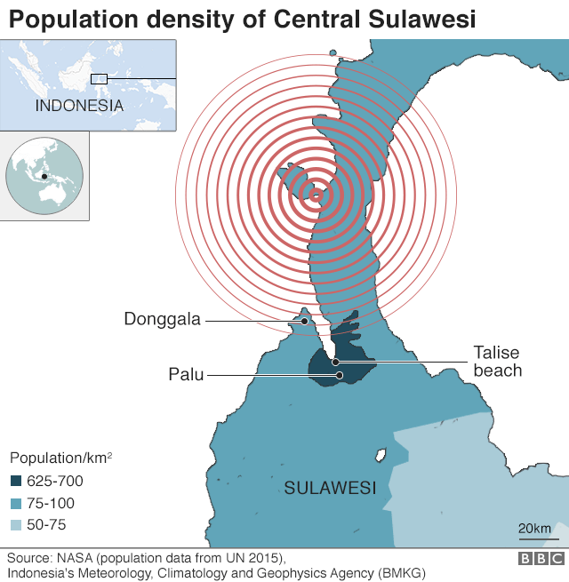
There have also been concerns about the town of Donggala, where the impact is still unclear.

The Red Cross estimates that more than 1.6 million people have been affected by the earthquake and tsunami which it described as a tragedy that “could get much worse”.

Palu map

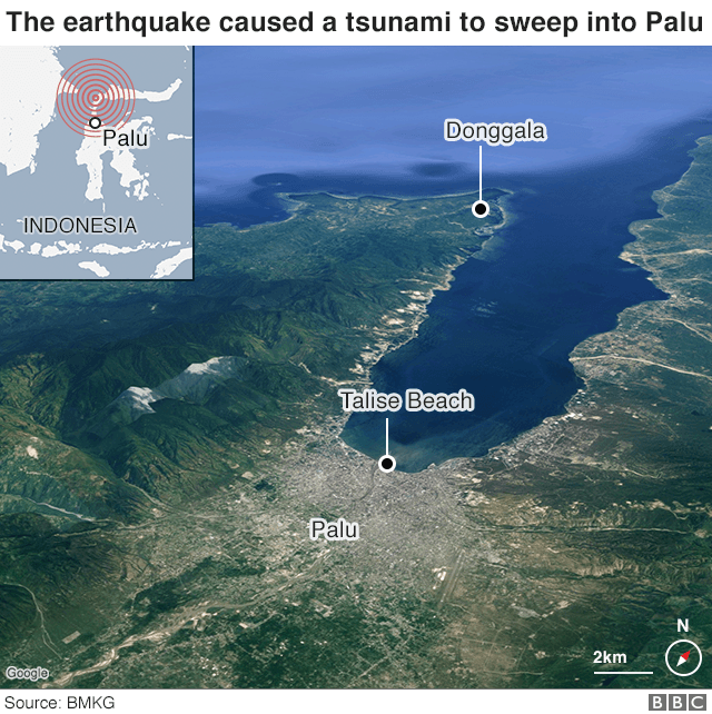
Strong aftershocks have continued to hit the island since Friday’s earthquake. President Joko Widodo visited Palu to view sites affected by the disaster, including Talise Beach – the main tourist area that was badly affected by the tsunami.

“I know there are many problems that need to be solved in a short time, including communications,” he said.

What is the situation in Palu?

Many remain missing in the city of 335,000, some thought to be trapped in the debris of collapsed buildings. Rescue teams dug by hand to free 24 people trapped in the rubble of the Roa-Roa hotel in the city of Palu, but there are fears that dozens more remain trapped.
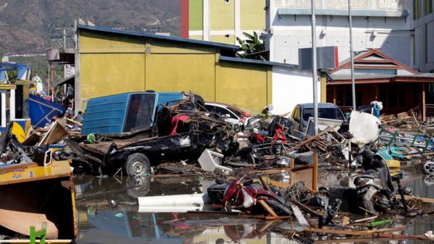
A tsunami-devastated area in Talise beach, Palu, central Sulawesi, Indonesia, 30 September 2018Image copyrightEP

Bodies have been lying in city streets and the injured are being treated in tents because of damage to hospitals. Anxious survivors in Palu bedded down in the open air on Saturday night, heeding advice by officials not to return to their homes as a precaution.

“It feels very tense,” Risa Kusuma, who was with her feverish baby boy at an evacuation centre, told AFP. “Every minute an ambulance brings in bodies. Clean water is scarce. The minimarkets are looted everywhere.”


‘Supplies running out’

By Rebecca Henschke, in Poso

In Poso, a four-hour drive from Palu, supplies are running out. State-owned petrol stations have closed as they have run dry. People are queuing up at roadside stalls, buying petrol in bottles to take into the affected area and to find missing loved ones. Supermarkets have limited food left and it is difficult to find bottled water. Ermi Liana, who is travelling with our BBC team, doesn’t know if her parents are alive.

“They live close to a bridge that collapsed. I can’t reach them by phone,” she says. “I can only pray they are alive.”

We haven’t seen any aid heading in and there is still no communication link to the town of Donggala.


Why were so many killed on Friday?

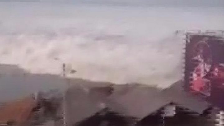
The 7.5 magnitude quake occurred at a shallow depth of 10km (6.2 miles) just off the central island of Sulawesi at 18:03 (10:03 GMT), triggering a tsunami, US monitors say. Many people were on the beach in Palu, preparing for a festival, and were caught when waves swept in. Video shows people screaming and fleeing in panic.

Map showing population density in Sulawesi
As well as destroying homes, the quake wrecked a shopping centre, a mosque, a hotel and a road bridge.

An air traffic controller at Palu airport died ensuring a plane took off safely after the quake.

What do survivors say?

When the quake hit, “we all panicked and ran out of the house,” Anser Bachmid, 39, told AFP news agency. “People here need aid – food, drink, clean water. We don’t know what to eat for dinner tonight. I just ran when I saw the waves hitting homes on the coastline,” Palu resident Rusidanto said.

Dwi Haris, who was in the city for a wedding, was staying in a hotel with his wife and daughter when the quake struck.

“There was no time to save ourselves,” he told the Associated Press news agency. “I was squeezed into the ruins of the wall… I heard my wife cry for help but then silence. I don’t know what happened to her and my child. I hope they are safe.”

With back and shoulder injuries, he is being treated outdoors at Palu’s Army Hospital.

What is being done to help?

Aid is being flown from the capital Jakarta into Palu airport, using the part of its runway still intact. Patients are being treated in the open outside city hospitals and at least one military field hospital has been erected. The regional head of the Indonesian Doctors Association (IDI), Komang, asked the authorities for immediate help.

“We need tents, medicines, medical personnel, tarpaulins, blankets and more of other things,” he said.

The UK-based charity Save the Children is sending an assessment team to the disaster zone.

“Unfortunately the more information that we’re getting, the worse the situation appears to be,” charity spokesman Tom Howells told the BBC from Jakarta.


Have you been affected by the earthquake? If it is safe to do so, share your experience by emailing haveyoursay@bbc.co.uk

Please include a contact number if you are willing to speak to a BBC journalist. You can also contact us in the following ways:

View full article at: https://www.bbc.com/news/world-asia-45697553

“Threat becomes a reality”: Hurricane Florence’s onslaught begins

Article By: CBS News

Hurricane Florence fast facts:

  • Hurricane Florence, a Category 2 storm, has started lashing North Carolina, with tropical storm-force winds carrying drenching bands of rainfall onto some beach communities
  • As of 8 p.m. ET, the storm is centered about 85 miles east-southeast of Wilmington, North Carolina, and about 145 miles east of Myrtle Beach, South Carolina, moving northwest at 5 mph with maximum sustained winds of 100 mph, according to the National Hurricane Center (NHC)
  • Hurricane-force winds extend outward up to 80 miles from Florence’s center, and tropical-storm-force winds extend outward up to 195 miles, NHC says
  • Forecasters don’t expect the storm to strengthen before it moves ashore, but they say the real problem will be water as it lingers along the coast through Saturday
  • Nearly 1,500 flights canceled through Saturday; Duke Energy in the Carolinas anticipates 1 million to 3 million homes and businesses losing power
  • 1.7 million people are under mandatory and voluntary evacuations orders, and more than 10 million people live in places currently under storm watches or warnings

https://www.cbsnews.com/embed/video/?v=1b92b2b8f87d58b8c3d400ac0117f983cf0d1104#xVdZk9s2Ev4rKL5stkqQeImH3uZyxpvYUWY8OdZKqUACJOEhCRoARyO79r9vN0nNjCb2JtlKYr1IBPr8vu5m66NzJ7lQzuqjw3vNrFSts%2FJ8d%2BY03f2VKF5yZ%2BXo%2B8vvb6Jz98PNy3CfyZNXb9bn%2F66Sl9%2Fl5Xf%2BDz9HzsyxVd9kLZM1iFfWdma1WWwWeWZasTPBHH5IY8F8Ps9Vs1lUfbZZyM1Cbxa%2B6yWbhZtuFl6wWXARCY%2BFMY2jIKNhKgrK%2FDijxTKKXeZxHicg%2BeBts4hC9z6I3M1imWaZyJkQae7HSy68PFrGgrsxyxMWixB9eAEVLW2UFpVgPJd2TzNRtqzn1APpMI3pZG%2F%2BrisxLdXJvGWNgLTOTq%2FJxZ1oZVuS15DV4XrNtGjtdd2XICRGAdqOAqKTRnHQ9maOEcwguo7n4EPZgNZ4oXPEv6oNfmXSAg%2BgsnTxM3M6iRw0%2Fnuj3%2F94bqPkCj3vO4wJdWZOrw%2BwD6jLjnFqrBasgVDmEwkj8I3gksFXd%2F8ceS%2Fw0jT2Qy%2BNvQms7cXr7YTP9upi%2Fe3J2cUWcYr8cAvR%2FS6heRP0CcRYKN0wyNdhXVfLfKi0zeKeNp0ob66%2Bdf4zw2S2d0xL1tptV6lWHMHhPQEjurq9uw34h3x5kh6B8Uz%2Fy0Az%2BP4%2F87Ysq4X9bOKF90N0%2F%2B6Ul8uf4k8nPhn4MpmPzv9A6kF5lKofPi35dGn%2B9c1pxd6%2F6aLHZIPy18lxtWtrxfhfkpa%2FhbDmTRc%2BTWmYmmg7fM6gsp%2Bn76R8pa%2BTm9OXcfEZ%2BlD7y3AHnv8AcTtZyKM04yPq%2FPxaXZ5UV3adq8dEB6W%2Fm7z4f5MHuZg%2BM7mWmeBnqrXDVP4IMmKH1eysrO7FEyHtrApWGziSJnKBkEKzNq%2BkEUcXF%2FcAzNFJmKy1QLPT6eC567QwMPfbvq5nY2BWWnTrXPZaA%2FitIC9qeGO1uSC56mtOMo2voNAlEvwKQ1RBNJPtjMDrrVDKEmMhU2J6XR6PwPGlvNvtjqGe4KgO%2Fmgx%2BaODPzr4o6FLR39UFRT90ckdHdzRwd1mge%2B28VX4Z9jD8PuhorIwYAUQSlm4LGiYJEvKktSnuZsAsmkc%2BGzpTAhycftp%2FKQh4r4TuRWcWEUaditIzVoOfNTkhZac7QlsB%2FgGn5F3vbGkVdpWiPCPssbmswpwfj0cnjGtatmyOTntLbGV6g2YGuioVAO8wBPJeiNbYBgeK3YnCKuhi%2Fme1AqMd2on9JzgYoELBdCroRo61XIoQnLOIBlyOpY10aIDr4YUWjXk1bTBkDNYYeaHtDu4UpVAtH5fxWAjs96qdc32zgqaF0o2vwVRbABpLlpsAH7oAKZhfavFSQ%2BpatwL3zqBy1nOs5xGLGHU84RPU%2B751IWGLUTCXDdznV%2Beqb4e1qm3zlSD5KtKckiYZHtAU%2FzzifywfMImx7wsi2gShYyGhchomrKYBokfZKIQ7tLFMplU1n12PswjB4cGdVOoKuIGqyBaud6j2JupxzawuAIhlsDqOHIGQLMaUN04K%2FJQweRQwf8A7FpTs76sUKeUrXlidJxy%2BThEttMp3HNo%2B%2FxwzYW5hb3RwaFwLu4wUvjdsfIggKBspRUNthJ8X0qcOW%2Bd3iA0eHINFTws6ng2Hk26Y%2FkYCZW2E9lhQx1wLGKXiwSW6syHpXrgigWFS10%2F9bwk9JJ4mR4URopG670RerLOWnA6c7Lba%2FCIRoMggKqpZSNhZoYPQFyrXucDFJnZLBjmmsGQ5FBnFofwEM9E%2Fxaj3z6Cgo%2BT%2B0liALBRpWZdJfNvxN4gGu9U9qJvRxxm%2BHQGtJdK7xHYlkPvDj%2BB1a63Qq%2B1KmQugcPDKWv31%2FID0lMKaDiNPJbia636bpDoW7QAiFssiL7BnujQSv0kNowW1%2FwWeYRbji01NOPN3z11c2QHLNW%2F6bmG8hj%2BoMAfKY10s3qy9hBCx2xFh%2FFEVW8BF7xSHCMCDoWxdAddU8H1Y%2FxDdA9dtxyCwrL%2BzXjGUD4FxEQp9ceADuPpeQxQU%2FDPDw6GaQ1q42B%2BDCagQ859x1HxIbKpzr5QBNJcCq0eVoRh4VkrqCgo6anhRANLCewo%2FwU%3D


WILMINGTON, N.C. — The big slosh has begun, and the consequences could be disastrous. The leading edge of Hurricane Florence battered the Carolina coast Thursday, bending trees and shooting frothy sea water over streets on the Outer Banks, as the hulking storm closed in with 100 mph winds for a drenching siege that could last all weekend. Tens of thousands are without power. The monster storm was moving in for a prolonged and potentially catastrophic stay along the Southeast coast that could drench the homes of as many as 10 million people.

Florence’s top sustained wind speeds dropped from a high of 140 mph to 100 mph early Thursday, reducing Florence from a Category 4 to a Category 2 hurricane on the Saffir-Simpson Hurricane Wind Scale, which rates hurricanes based on sustained wind speed.

Forecasters said conditions will only get more lethal as the storm smashes ashore early Friday near the North Carolina-South Carolina line and crawls slowly inland. Its surge could cover all but a sliver of the Carolina coast under as much as 11 feet of ocean water, and days of downpours could unload more than 3 feet of rain, touching off severe flooding.

North Carolina Gov. Roy Cooper said he knows many people are watching the changing storm predictions and categories, and he’s concerned because some are even saying that “North Carolina is getting a break.” It’s not.

“Please hear my message,” he said. “We cannot underestimate this storm. Don’t relax, don’t get complacent. Stay on guard,” he said. “This is a powerful storm that can kill. Today the threat becomes a reality.”

South Carolina’s most popular tourist destination, North Myrtle Beach, is like a ghost town. It was nearly empty Thursday as the first bands of Florence approached. A few locals briefly walked into the sand, but were quickly sandblasted back by stiff winds. One man tried to skimboard, but gave up after a few minutes as winds from the land cut down the waves. He called the ocean “Lake Myrtle” as he walked back to his car.

https://www.cbsnews.com/embed/video/?v=1b92b2b8f87d58b8c3d400ac0117f983cf0d1104#xVdtc9u4Ef4rHH65dkaQ%2BCZS0pdOrdjnXBKPGsfjplFHAxJLEjEJMCBoWZfpf%2B8uSdlWLtfr3cyN9YUisG%2FPs7vA8qt7LwVod%2FXVFZ3hVmrlrnzfm7h18%2FAe8tfCXbn%2F%2Bry%2BmYd%2BVRS74OraNnN1%2Ferj%2BqH%2BSf0UZ1%2FqW3fi2rKrU8VlheKltU272s62syxtFezbcIp%2FZGvRfDbNdL2dlV26ncntzGxngecvtjNvuZ354XYWxiLOk8BnaeQtWJR5CVvEQciyKMwhyJMYeLadPXrbzuLIewhjD32FIsi8MIyjKI%2FTNINskUCezYUfJxAlvQ8%2FZKBYrg1kvLWsqLjRLfPjeTIPIjaamn5uCkKkG5kpXgMiWp9dO%2Bf3oKQqnCsEdNzecAPKXlddgUIwCDA1CEAjWy1Q25%2B4LfCWiHV9l16KGrWGDZMR9WXV0iOVFlOAKnOPfhO3kUR%2F15wl75Om2oRiTZ4PDcVEOhO3M0fGe8JlwwVrrQFeYyjTkf%2BB8xqE5PhoHr4l3Q%2F95XKRBHESJ97A0%2B78ancx8rT7sedpd3V%2Bu%2Bu5CoMdRvh%2FC07rsFtgrMh7zRG3y5umkllfbNvZA6sbKG7ev3X%2FMyFQu3tuJFd215RawQkt%2FjNSbi7eX368vX0btNnZCSnf6L8cRb3%2FP4jd8rQC%2B6vgzbsPUfCwebNbfvC%2FD3408HLohwD%2BIHxtfx27vRSbVx%2BTN1f%2FfP2P72Mn7ZcDjt5%2FB%2Bq9zOUJ1CR63vq%2BV68XXxpzc7l%2Bluhe6RcIhd6rSnPxZ2ELgh0GN62b6Dm0%2Fvog%2BxHBCYsTMMEJmM9vTX64mn%2BZ5%2BrnJzBh8SJQgv8NBbG0XdpmRqYg1lrZ%2FsT%2BijKwp8p2V9Z08EzIuKucVy0uyTb2sMZyw1VWyhZONs4fkJqTlWixMUBmx9Xec9MYaPFOUF1VTYbArLTk1r0tQTl7WVXOZWcMVpUC56JCpCoDp%2BZ34FRcCTRV%2Fe2E2OFG3u%2F3p6SOoPdolZFVVh6tsny0ysgqO1plwXZGt9hw6f0ePQqn6yshT%2FmChyln8YJ7LAqwNRf5ImUhzNNoHnhBJmJ3xC3gDjVeK%2BdKG1s6a8xkJRWfOLYE5EEJR7YOr7CxxcFJK72nSxp9OoZLRXsIk5aopqbOWWe%2Fx5ts1Q%2FWgYcGMgvCsfqUSadTVlbOhZGCH6bO7dnZO6cGCxpj0QVONs47KLhyhjojp5jl7I7cUpStxRKbHgE1Rte6BOLhw1HqlyFRN%2FHO6k3FD%2B4Ke%2BhokapQtueKqlAcy5AbHK0q%2BHtnS21oZvvkhp7gmUgzFiPXzPchYEvhB8zDzskBefdSz%2F33N6pX%2FbzzyR1LxPlLKYXAeksPyDn89Zl8PxgK8LmfpjHOaBFnUQ4pWy55wsJFEKaQgzf36AYeVTZd%2Bqo%2FFlzqXuYtmR86XrgK45XnP4l9GAt9i0MlZtU6KWAKAZPs4Gsl7WHrrpzHcnOO5fZD62jVVrwrStIppGqfGR0Om2zo5N24ivsCey87bgto73Cwc6kzX8E9RYr%2FG14cBYiUnbRQUwfg81JS439yu5aooZVrrKB%2BiKa1YWnUxY5uMEB5j2UL6XGE7HnME0%2FAIkxZGkA%2B5IqHuce8YOn7i8hfJPPlUWFI0WC9a8GM1rlCpxM3vbtGj2Q0DEOsmkrWEg%2Bu6JGIa92ZrKcibbczTlhTPKkE1pmlk7CPZ0z%2FjqLfPZFCr6P7UaInsNaF4U0pszdwaImNzzq96NTAw4Te1pj2QpsDEatEh9cw%2FcWsNp0FszE6l5nEHB5XuTpcy58pPQUogRRj%2BAX8aHTX9BLYjmgBGbdUEF1NPdGQlepZbBQtzeGK8oi7glqq78CbP%2BtQzCgLKFf9pocKy6D%2FUsCPGUNp5RXrj4knBw23JWv0HgzTnUX8tKUFfWJgrgC%2FX%2FbYHSVuP0VHZx577K55HxSV72%2FGM4TyHZjZmDoWDAEdj6FvY3j8qFJ0TKPacEw%2FBROyHnPXCFJ8jGyspxeKQLaXYPTjfdxPGBuNlYOlOzYW1DgB4EDwXw%3D%3D

Latest Hurricane Florence advisory from the National Hurricane Center

The hurricane center said in its 8 p.m. advisory Thursday that Florence is centered about 85 miles east-southeast of Wilmington, North Carolina, and about 145 miles east of Myrtle Beach, South Carolina. The storm has maximum sustained winds of 100 mph and is moving at a speed of about 5 mph. Hurricane-force winds are blowing 80 miles from its center, and tropical-storm-force winds reached up to 195 miles from the eye.

Hurricane-force winds are moving closer to North Carolina’s Outer Banks and the southeastern part of the state, the NHC said.  Florence’s center will approach the coasts of North and South Carolina later Thursday. It will move near — or over — the coast of southern North Carolina and northeastern South Carolina in the hurricane warning area Friday.

“A slow motion across portions of eastern and central South Carolina is forecast Friday night through Saturday night,” the center said.

Forecasters warned that Florence is deadly because of its size and slow forward speed.

“It truly is really about the whole size of this storm,” National Hurricane Center Director Ken Graham said. “The larger and the slower the storm is, the greater the threat and the impact — and we have that.”

NWS WPC

@NWSWPC

Life-threatening, catastrophic flash flooding and prolonged significant river flooding are likely over portions of the Carolinas and the southern/central Appalachians into the middle of next week, as is expected to slow down as it approaches the coast and moves inland.

The NHC said life-threatening storm surge and rainfall are expected. The storm is expected to push up to 13 feet of storm surge and dump water on both North and South Carolina. The forecast calls for as much as 40 inches of rain over seven days along the coast, with the deluge continuing even as the center of the storm slogs away over the Appalachian Mountains.

The result could be what the Houston area saw during Hurricane Harvey just over a year ago: catastrophic inland flooding that could swamp homes, businesses, farms and industrial sites.

NWS

@NWS

Florence is a very large storm, with an area of winds greater than tropical storm force stretching more than 325 miles across. This will generate a very large area of dangerous storm surge flooding in the coming days.
Follow your local NWS office: http://weather.gov/socialmedia 

Tornadoes also remain a threat. The NHC said it is possible “a few tornadoes” will hit eastern North Carolina through Friday. The forecast track throws Georgia into potential peril, as well, as Florence moves inland. On Wednesday afternoon, Georgia Gov. Nathan Deal declared a state of emergency.

FEMA urged people to have multiple ways to receive local weather alerts — through a weather radio, phone and TV. It also warned against the spread of false information and said it created a “rumor control page” for Florence that will be regularly updated.

https://www.cbsnews.com/embed/video/?v=1b92b2b8f87d58b8c3d400ac0117f983cf0d1104#zVfbbtw2EP0VQS9tgaVXt92V9i03x45T27FjBEFULCiSWtGWSJWkvN4E%2FffOSFpfcmngoEXzJPEynDlnzlCjT%2F615EL7y08%2B7wx1Uit%2FGc3iid%2B0N2eiPOT%2B0n%2B%2FenP2pA7qg%2BJd6FbZ6fvEXF4cNfzy%2Bsnq%2BNWflT%2FxXdU1haKyhu2Vc61d5tN8ygqrxMZGe%2FAirYPj2R7TTT6tuiKfynxq8mkUhGk%2BDbJ8GsYwSpOYiiQjZZmFJOHzOUlZwQgVKSvjBRNBwvPprbd8Ok%2BCm3ge5NMyThfRjCVpOUuSKGXRPIzKYMajYhGmJS2HaEjZWcBICmEdoW1rSakN6VpOnbAEFqrOGMmoEqSstRGKCXLrjYTz2SJKYjI63bts14hdt5Ip2gjA%2Fuzp%2BfFu6pSCvTuvuzUsoHNYEK20msPOcOJbQS3S7Yc%2BDtYN7B4WDMOEVLXFRyEdJAZNgiCY%2BK3ElLysLq5mYr86mR2%2BRn%2FbFr2jxcTvzC4LfRJkSzmxzgjaSLXeG3My5KERXFJ4tDefJyKMw2yRJrNwNp8l%2BRRxrQbuVo%2FgbtWrazXwlq6Cf%2B2gvSbuUsAKhg0F1nw4pgYTFHA%2BvSFNK9YXZ6%2F9vyZIyuqaGkmVW7WVVuKbpLrq1f5hbK42q3cvHpD6mf3PTHEf4Q%2By42hRC%2FdNetrj%2BeHJ0exqf35YfJ2e8YCfmZ8hxB8kSLtvs3N49vJiHYcn7%2Bfq96%2Bzg9Y%2FMzUQ3yN4idcPqIiS4B4ZqhKX2Ul1WX40mzsy4vWX%2BLneqFpT%2Fj8ij1YQ%2FF7TJveB9xswggTBbmQpH8BdPICb0ZevisXRm0rF9%2BD2Rj8n4MU%2FAwbEtissM7IQ%2FJlWrv8yfYI9YoP14y%2Bd6cS9TcZflrS2MCXtPAAll4YqVkkrHiy8uAH6Hswk6akReOw423tuWyMsfPtUV9eTITAnHbr131bCQ9gewvYgeG%2BE7WnlHexge%2Fsj7Af0Dz3JZrN5SP0I%2FBFk5lP8YA%2Ff9UeYYTBdr5ekZIsiziKyiOIIuhwWELqIKJmFWZgkcRbzLPJH5FxcgcWX0DxpPXHTCuYE95z2CgP3h8dpQ9f4spGK24kHvjWH8cSjisMkFxbIpdxr9UYYT3eOroXd854dv3jrgQYdMPqcKu8JuxIgDOVdaqmsh6pDJ1xa1lnrVXqDQziqhSanPxvau63HtFJDRBvpKs8JVild6%2FUW07PVnfGG79MOXGt0oyuBnDx9RFZBJbRz%2BrSmW38JVQiqYleAEjUq7QuFGuU7kVIDbWctnnSu0gb72Q9%2BHHDKOLSVc5pSEoYiIhkPIxJA5ZUipUFQBP4fn5ke9x3eB38Uj%2FdrJTkXyiu2tVTit3v7%2B6aZi5CGRQH96zyhJClFQbKMLkicRnEhShHMAlTEaHLaFc%2F7i8XH6idBRsLYC%2BJlPF8G4d22t2MZ5NCrQBod1AJoGHiiHgxr6ba5v%2FRupeftpPcLMmlr2q0rtAGF2HuHDtcVG%2Bp8Nc7COofKZLtlUM4VtLU%2B1u1zcY2RwnsL8hk3ICkr6USDxQHPA4nXwge%2Fs0gNzpyDNPofDJwbpkZbqPcWApTXwtuIYtdA9zyWi4CLNC5IEYlyyBWNy4AEURaGaRKmi1m2MxhSNJzeWWHG06nS2HsXV%2BfgEQ%2BN4xhUU8tGwrWW3BJxDgJlYmjW8ylFrAXcYxx05vCe7OMZ07%2FC6Fd3pOBwdD%2Fu6Als9NrQtpLsSGwtsnGpi%2F1ODTxMcPQM0r7WZovEKt5BK4CvkNW2c8KcGl1KJiGHu1mqtufyI6ZnLRQHiiH8tXhpdNf2OzqFJwDjDgXRNVgTLZ5S34sNo8W%2FEYV5hFWOJdVX5MV%2FdF0yTALM1991UIMKCA7hP89gVmkNDRLQf%2FdH1lJXkf4GI8MNRnb3HKkxDkc2UBwVLN9FY6hU5La4Zn1QqN7vxjOE8pX%2FQjZmjkRDQLtb6PMYgCDBKEwobWAbo0bDjUHvgolJj3kk8TayUU7%2FUwTSHgijbz%2FWfYNyqkE4oNyxrkQD7QF0C38D

Hurricane Florence watches, warnings & evacuations

About 5.25 million people live in areas under hurricane warnings or watches, and 4.9 million more live in places covered by tropical storm warnings or watches, the NWS said.

The NHC said in its advisory that the following watches and warnings are in effect:

A Storm Surge Warning is in effect for:

  • South Santee River South Carolina to Duck North Carolina
  • Albemarle and Pamlico Sounds, including the Neuse and Pamlico Rivers

A Storm Surge Watch is in effect for:

  • Edisto Beach South Carolina to South Santee River South Carolina
  • North of Duck North Carolina to the North Carolina/Virginia border

A Hurricane Warning is in effect for:

  • South Santee River South Carolina to Duck North Carolina
  • Albemarle and Pamlico Sounds

A Hurricane Watch is in effect for:

  • Edisto Beach South Carolina to South Santee River South Carolina

A Tropical Storm Warning is in effect for:

  • North of Duck North Carolina to Cape Charles Light Virginia
  • Chesapeake Bay south of New Point Comfort
  • Edisto Beach South Carolina to South Santee River South Carolina

More than 1.7 million people in North and South Carolina and Virginia were warned to clear out. In South Carolina alone, more than 421,000 people have evacuated, the state’s governor, Henry McMaster, said Thursday afternoon.

At a news conference just before 3 p.m. ET, he urged those in evacuation zones to leave now “because time is running out, and remember this: once these winds start blowing at that tropical-storm rate, it will be virtually impossible for the rescuers to get in to rescue you.”

“So if you have not left, if you are in a place of danger, if you are in these zones, now is the time to go because that window of opportunity is closing on you very quickly,” he said.

https://www.cbsnews.com/embed/video/?v=1b92b2b8f87d58b8c3d400ac0117f983cf0d1104#1Vdrj9y2Ff0rgr60BZYzes2MNN%2F8yGYTO9uFZ7eG4SkGFHk1oi2RCknt7Nbof%2B%2B9kmZfWSdIETT1J0l8Hp5z7tXll%2FBaSTDh%2Bksoe8u9Mjpcx1EenYRtd%2FMOqh9kuA7fJm%2B9PN9cffiUmM7nZzu77N%2FtsrP85Y%2Fl6sVlEZ6Evu7bUnPV4PDa%2B86tt%2FPtXJROw8GlM3xRzuP6YiZMu53Xfbmdq%2B3cbudJFOfbeVRs53GKM5aLLF8UK7YUKbAsTgpWipyzRZKLgmcpRJnczu92286XWXSTLqPtvKxgEecVX8U8j%2BQi4VmSLwsQCwmQV2U5omFV7%2FCQzJne10xwaxqlOduba7DaWHbgVjvma%2B7ZQWlpDswbBtdc9NwDU46Jxjil9%2BwOAouXi1UaF2xCMvvU7YkQ0ymheQtIyKuXm%2FNj0wW3oP2m6ffYQYiwAzrljMSR8UnogDsSIYxD%2Bti3OHrssIJkqhtHj1J5lIumRBGK1SnSaZOc68voor6KLhXtd9vR7jTjJOztUZpBGdVxyZy3wFs8zWwSahSnBak4Prqbp%2BrEeM48juO0KFbZdk7n2o2E7r5GaN1bqwTXwKrG4NEF%2FDqxu8GQu4HUJN9F%2F5tdZm3a58hSZWzLke%2BQd12DC1JAbOc3rO1gf%2FXubfjvE6Jzd82t4trvutpo%2BKocP29O%2BU18%2BmJTn98%2BkuPJ%2FG9WnAH%2Bf0md52UD%2FqvcnXb6dZMVq9PNPw7Pczct8M2SN%2BL%2FHeyl%2B0dsJVn0gK8fP1zu2uynD%2B%2FTF%2FU9X%2Bn%2Bl%2FwgQN0YLv9PmYmzHZ5s1nbZQ1aGAQQve%2Boj479uovc%2FmNM33c%2FxG6iy501Es79ZByH432Gfg6rUI6ZWjwyk8lOtRPKpWb5M77kaJn2DFlr9uoWQDteXTlhVgnxltB9%2Bsl9wDBwoLMO1tz08GGTDdcUbh03KLSO0RWW5FrVy8Kjjuxvk9lFLll9YoGWn1mHnrrPg8Deu%2B6Y5GYF55WnbcEN8BK8mPoIjH8FQlwRUlwQjD4E3wZGH4OzIVnA6sRUoF0zUPNJvrMsOh8Nj7SZy%2Fig1tnMqXsYa549ak47RD1aVcbmKi1XK4ixLWBbxmJVFErMoE5EQyVIWaRVOvEr4jDP%2BXlVKKOQ%2FUDp4SjG%2FhoDroO8kUXmJuJzkt4HRz9HKtQxQvY6PxbIL0F8oCwSdOYCt%2BiZwHh0XcNzK4zu3HmTQcFfjEYaBV7PNLBCGOz%2FDzeBe4t7ucaivjYPgUJvA1aZv5L3IKHgDI1gcZrCrA9M1Q0cJEypcgRB1eDijab0BV4BH5ntwsyMt2N%2BaGojN7831bB28%2F6WpnrMS2pf33lw0%2FDZcY%2B5Au4vP1IHBo9x3moJHHqMHz65EAy%2BQbmPpIvExTCPJhSwFW3Is6uMYElbIOGER5osKch5FZRT%2B88nU86GK%2FhhOjg3%2BWispQQflLQoIf3swfritSIh5XJZLli8zzrIKSlYUfMXSPElLqCBaRFRzTVMu%2BvL1kA5DylksKlicBlG6TpfrKL4fdjnF5xZvOvhj8Mg4Bg64gAf42Sh%2Fuw3XwZ2ng6On%2F%2BLQSK7h%2Fb6mOXul3YNFxyQrxgS0m1qxX2LKEMduCe4zXh1CSiiv4ZqQ4nuHek4DiJSd8tBS0OHzTFG%2B%2Bhj2jqihlg2I8WpHbWPTNBcTUYcAFdrqAOXxkjLwWK0iCXlasjKBatSKp1XEoqSI4zyL89WiOE4YJRpX7x3YaXWuDd1vys8b3JEWTdMUXdOoVmG%2Bze6IwJC0AsYL0XbO6awlJliJPvOUwAc8k%2Fw7Qr%2B7J4U%2Bp%2B2nEQOBrdlb3tVKvIFbR2x8MuVpr0ceTujrFcq%2BN5ZKczR%2Fjz98ekVVu96DvbCGcgZqeGzl%2Bnaj%2FkXy7EFLpBjh7%2BF7a%2FpuGNFrWgEZ92SIvqWY6GiV5gE2Qks3Pk06Yq%2BkkBpC8urPyNGCFMJZzW%2Fu3qBFGH3i7duS5LxhQ6q7367jCGzIN2zMN9RlJN2WUUdweKXGyKnhIVbLlWZ3kbcYQJG1fxPPCOWZQ4tJVpaMgI4p6ikG9BUIzMIMyXtI6H0aYMOZx%2F%2BCu0M2ee1PQqDcGVhzV2IMNdcF6km2noIOWixqsMb5Dw%3D%3D

An emergency management official in one of the most populated areas of coastal North Carolina said Thursday afternoon that winds from the storm have arrived and other impacts won’t be far behind. New Hanover County Emergency Management Director Steven Still said residents who didn’t evacuate should expect 60 mph winds by Thursday n ight that would eventually increase to 100 mph or more. He said residents “can expect to have that wind to the tune of 100 mph-plus stay on us for considerable period of time.”

He said landfall is expected around 8 a.m. Friday in the Wrightsville Beach area, and that the area could see 20 to 30 inches of rain and beaches could get 9 to 10 to feet of storm surge.

SCEMD

@SCEMD

6 inches of moving water can knock an adult off their feet. STAY AWAY from moving water!

Thursday afternoon, North Carolina Gov. Cooper said more than 1 million people have evacuated. At least 12,000 evacuees have settled at 126 shelters in the region. He also said that 2,800 National Guard troops have been activated.

President Trump took to Twitter again Thursday to warn about Florence, urging people to be careful and saying “we are completely ready” for the storm. On Wednesday, he said, “Don’t play games with it. It’s a big one.”

Power outages along the coast

Power outages in North Carolina have increased as a weakened and slower Hurricane Florence moves closer to the coast. The two major electric utilities covering the state — Duke Energy and Dominion — and a consortium of electric cooperatives reported more than 80,000 customers without power as of early Thursday evening. That doesn’t include numbers from dozens of city-operated electricity providers.

Almost two-thirds of the reported outages originated in Carteret County, along the coast about 100 miles (161 kilometers) northeast of Wilmington, North Carolina. There were also several thousand outages each in Craven, Pamlico and Onslow counties.

The numbers are expected to soar as the storm’s winds and torrential rains sweep over more land. Duke anticipates 1 million to 3 million of their 4 million customers in the Carolinas will lose power from Florence.

Hurricane Florence could inflict the hardest hurricane punch North Carolina has seen in more than 60 years. In 1954, the state was hit by a Category 4 storm, Hurricane Hazel.

“Hazel stands as a benchmark storm in North Carolina’s history,” said Jay Barnes, author of books on the hurricane histories of both North Carolina and Florida. “We had a tremendous amount of destruction all across the state.”

Hurricane Florence

A spray painted message is left on a boarded up condominium as the outer bands of Hurricane Florence being to affect the coast on Thu., Sept. 13, 2018, in Atlantic Beach, N.C.

 GETTY

Hurricane Florence affecting flights & car travel

Airlines canceled about 1,200 flights and counting. As of Thursday afternoon, total cancellations within, into or out of the U.S. was 603 for the day, while 650 flights were cancelled for Friday, according to flight-tracking service FlightAware.

CBS News correspondent David Begnaud reported this week that people living in the barrier island community of Wrightsville Beach, North Carolina, were bracing for a possible direct impact. Long lines formed at service stations, and some started running out of gas as far west as Raleigh, with bright yellow bags, signs or rags placed over the pumps to show they were out of order. Some store shelves were picked clean.

“There’s no water. There’s no juices. There’s no canned goods,” Kristin Harrington said as she shopped at a Wal-Mart in Wilmington.

Hurricane Florence

Lisa Evers and her daughter Amanda Hamilton decorate their storm shutters before evacuating ahead of the arrival of Hurricane Florence in Oak Island, N.C., on Wed., Sept. 12, 2018.

 REUTERS

South Carolina said it is planning to end the reversal of some interstate lanes that were switched to help move people away from the state’s coast. Department of Public Safety Director Leroy Smith told reporters that, starting Thursday at 6 p.m., officers will close Interstate 26 lanes that had been switched from eastbound to westbound to move people away from the Charleston area toward the center of the state.

Many officers are on the road during lane reversals, manning each exit and ensuring drivers don’t drive around barricades. The change allows agencies like Smith’s to pull back their officers when tropical storm-force winds are expected to arrive in the state.

West Virginia prepares for Hurricane Florence

West Virginia agencies are mobilizing to respond to problems arising from the storm. The governor’s office said in a new release the Division of Homeland Security and Emergency Management activated its emergency operations center Wednesday. The statement said 50 National Guard members are prepared to assist in locations across the state.

Nearly 70 tractor-trailer loads of supplies have arrived at the Guard’s 167th Airlift Wing in Martinsburg. In June 2016, a series of thunderstorms pelted a wide swath of West Virginia. Nine inches of rain fell in 36 hours in some areas, leaving 23 dead statewide and destroying thousands of homes, businesses and infrastructure.

The NWS forecast said up to 4 inches of rain is possible in parts of the state through next week.

Four storms churning in the Atlantic

Florence is the most dangerous of four tropical systems in the Atlantic. Tropical Storm Isaac was expected to pass south of Puerto Rico, Haiti, the Dominican Republic and Cuba, while Hurricane Helene was moving northward away from land.

NHC announced Wednesday they are now monitoring a fourth storm that is far out in the Atlantic. That storm is Subtropical Storm Joyce. It has maximum sustained winds of 40 mph and is moving southwest near 6 mph.

https://www.cbsnews.com/embed/video/?v=1b92b2b8f87d58b8c3d400ac0117f983cf0d1104#xVdbc6PGEv4rFC85qdJYXAQCvTle73pvjstanzo5S0o1MA3MGhgyDJa1W%2Fnv6QZkWXtJKkkl1otgpqe7v68v03yy76QAZa8%2B2aLX3EjV2Ks4mNl1e38N%2BUthr%2BydePncTc1%2F0%2Bh5pd7%2BdONF%2F4%2FX6cfFT%2BLd4vTZBbdntin7Om24rFC8NKbtVsk8mWdp18C280%2FwQXYGtWcnmaqTedmnyVwmc53MPceNkrkTJ3PXT%2BZRtvBC8FwWcx6zRe4ELPYyl0VBnrpLzwHXQ6kHa8k8XDj3fugk89zxgzyIQm8Z%2Bsso9V3Xc5aL1HcEz8MQcrLh%2BgwalldKQ5MBK%2FCBuWGwDLyYTYpOPrQF4VGtzBpeA%2BI5%2B2Ftnd9BI5vCukQ4%2B%2B0rjmrMuuoLFIJRgDWjALSyUwJPuzO7A94Rq7Zr00tR46lxQ2fEe1l19JdKg%2FzjkcCh38xuJZF%2F54WXcCpDmb56RZZ3LflEZ2Z2r%2Fd8D3TLlgvWGQ28RldOJvZHxmsQkuNfe%2F855a7vxjHytvCjMBpZ2pxfbt4iSSVwsXmBLG2uz6%2FenJ6db4it0A026OOfED2p%2FT5Cf3Ola47Ybd62lcyGbEvm96xuobi5fmP%2FOiNgmzuuJW%2FMpi1VA0fUuI%2BI%2BaU%2FDzZhKK9uvOsjYj47%2F5Q0DR78RfSGpxWYb8J%2FnTXxfX35%2BvVH%2Fuzr8CcFT4l%2FdOEvEqDMt9Hn8c36oo9e%2Fi9Is6%2Bjp9NPCR3t%2FwncfnEE1Vs8bgFvTzdndf7OvLjm8QGsX3yJT6htUyku%2FkFk%2FgadO6nbxWNgwx1CFhYEZitzeQRneQRn86GRF7f6pXrx9scDnOHQ0wBa%2Fj4gRNT1aZdpmYI4U40Z%2BvcnlIEt5be9MrqHR0LaXuW86nBJdqGDmZZr3mSl7OBo4%2Fwe6TlaWURXGkjttDpYblsNHd4QTV9Vs9ExIw2Zta8B7xadlaA7C3Vlt9ZFrzVmWAPW8%2BmWs4yyUIOQmbFMCVYD98Yq92JHjI%2BX9na7PWZ74kIfjLHBGHvQcrhSjWKTMYbGGBk7iCVzugDH%2B%2FLvayPX%2ByGhhB%2FhTb9w2CKOBQ4NscfSPAoZBJgKgciDkAf2RJ2AWzyxziQGEUeSzsJL3OIVdgSxswqOZjTd84IbbuVa1d9gNAVjQH9JLLV7K%2FliZEhsizJAaesV5LlFWWjVYKytNKXFrcsfT0%2BtPSNWt3fO2pbKkp1V8Z7SB3WVsiiZARTawuCr1UHTKQy%2FbNArcqOWQlRgqXx46wxm9MkefIuAVAnia6lD6vcIqYh5b9RVxXf2Cgt3L0FpL7vzhtJe7POea5zrKjjtDQKkgfG9TVNXJtKMhTzizHXBY7FwPeZgseYQccdJHfvnz45eDuPWe3tKPus%2FJUKBxkp3lWzg%2B0fyw1QqwOVumoYsChccow4pi2O%2BZH7k%2BSnk4AQO5ch05KpPnw29yKaGwZyYub7l%2BCs%2FXDnuQezdVFkJTrSYEwYDjTUAmCYYH15Js0vs1aF8rH2qftdh6DsMVFHSmUI23SOlY4fLxtaxmVZxX2CxZ%2FttAd0tzpU2tYJncEee4nPLi70AkbKRBmqqIvy%2FkNRp3tt9R9TQyhqycYCntXFpOovJ1aKD8g4wc9L9BDvwmC8dAZGfstSDfIwV93OHOV7sutHCjZZBvD8whmjU3negJ%2B28QaMzO71do0VS6vs%2BZk0la4mdcvFAxFr1OhuoSLtkzglriq1RYJ4Zar2DP1P4N%2BT95kAKvU7mJ4mBwFoVmrelzF7DriM2Pqj0OZbLwMOM3s4w7IXSOyK2ET3e%2FvSIUW17LOErrXJJBZftV3mzW8uPFJ4CGoEUo%2FsFvNCqbweJviENyLihhOhrqomWtFSPfCNv6TOgoTjirqCSGmrw5t9ttxnFBl%2BrP7RbYXIMny%2F4faUp2LxiQ%2Fs4mGux57BWbUEz1RtkhbaUoO8ejCB0hk1t6ZGvmsuGPdRcMDhFSf2H%2FoyufAV0NgWUeaND%2B%2Bb0uQ%2BYUZBxXGiURrGMa4WNhB%2Bc8dmAuW8FHXzwbMqyJ%2FJAdheg1cNYMIw6VwrzCRN6KjeocRDBueQ3

View full article at: https://www.cbsnews.com/news/hurricane-florence-category-2-path-tracking-latest-weather-forecast-north-carolina-2018-09-13-live-updates/

Another mass fish kill hits Indonesia’s largest lake

Article By: Ayat S. Karokaro

Millions of fish in floating cages died suddenly this week in Lake Toba, the biggest lake in Indonesia. E. Naibaho, a local aquafarmer, noticed the fish in his floating pens moving in an odd manner in the days leading up to the incident. The water had become cloudy as well.When he and his workers went to feed the fish on the morning of Aug. 24, none of them could be seen rising to the surface. They tried adding oxygen to the water, but it didn’t work. Before the long the fish began floating to the surface, dead.

“My capital is gone,” Naibaho said. “Hundreds of millions of rupiah.”

Another farmer, M. Nadeak, estimated the total losses for all the farmers at 5 billion rupiah ($342,000). “Our economy is disturbed,” he said. “That’s going to create social problems.”

It was the second mass fish kill in as many years in the lake, which is located in North Sumatra. In 2016, millions of fish also turned up dead. Researchers attributed that incident to a sudden depletion of oxygen in the water, the result of a buildup of pollutants in the lake, unfavorable weather conditions and unsustainable practices by local aquafarmers.

Where the 2016 incident was concentrated in Haranggaol Bay of Lake Toba, this one happened in Pintusona, just off the giant island of Samosir in the center of the lake.

Other Indonesian lakes have experienced mass fish kills, too. In 2016, 3,000 tons of fish died suddenly in Lake Maninjau, West Sumatra — twice as many as that year’s incident in Lake Toba.

Both Toba and Maninjau are among the 17 lakes classified by the Indonesian government as being in “critical” condition, meaning they suffer from a host of environmental problems. Last year, government officials and academics from around the country gathered in Jakarta, the capital, to declare that a national body should be created to direct attention and funds to the nation’s more than 800 lakes.

With regard to the latest incident, an initial study by the district government indicated that the proximate cause of the fish kill was a rapid change in the temperature of the oxygen-poor water at the bottom of the lake, causing a sudden upwelling of water that made the lower layer rise to the surface, said Jhunellis Sinaga, the Samosir district government official in charge of fisheries. Waste produced by the fish farms contributed to the conditions behind the fish kill, he said.

Jhunelis estimated that the farmers had lost a total of 4 billion rupiah ($273,000), with 180 tons of fish dead. “Water samples, fish carcasses and more are being examined in the laboratory,” he said.

Local residents helped government workers carry the fish carcasses, with heavy equipment used to bury the fish.

The lake’s waters have been polluted by waste from the fish farms, according to the Lake Toba Lovers Foundation, a local NGO. The fish farms are run by local entrepreneurs as well as by several companies, said Maruap Siahaan, the chairperson of the foundation.

The foundation is demanding that the government halt all fish farming activities to improve the water quality of the lake.

As part of its plan to turn Lake Toba into a tourism hotspot, Indonesian President Joko Widodo’s administration has announced its intention to clean up the polluted lake, including by cutting down on the number of fish farms there.

View full article at: https://news.mongabay.com/2018/08/another-mass-fish-kill-hits-indonesias-largest-lake/

7.1-magnitude earthquake reported on border of Peru & Brazil

Matthew 24:7; Luke 21:11

Article By: The Associated Press


LIMA, PERU—The U.S. Geological Survey says a 7.1-magnitude has struck in eastern Peru, close to its borders with Brazil and Bolivia.

The quake was recorded at 4:04 a.m. Friday at a depth of 609 kilometres (378 miles). The epicenter was 135 kilometres (83 miles) west of the Peruvian village of Inapari, and 226 kilometres (140 miles) west of the Bolivian city of Cobija.

Thousands of residents remain stranded at the Indonesian island of Lombok as they struggle to recover from earlier earthquakes which claimed the lives of over 450 people in recent weeks while at least 10 more people were killed after tremors shook the region. The U.S. Geological Survey says a 7.1-magnitude earthquake has struck in eastern Peru Friday, close to its borders with Brazil and Bolivia.
Thousands of residents remain stranded at the Indonesian island of Lombok as they struggle to recover from earlier earthquakes which claimed the lives of over 450 people in recent weeks while at least 10 more people were killed after tremors shook the region. The U.S. Geological Survey says a 7.1-magnitude earthquake has struck in eastern Peru Friday, close to its borders with Brazil and Bolivia.  (ULET IFANSASTI / GETTY IMAGES)

There was no immediate information on damage or casualties.

View full article at: https://www.thestar.com/news/world/2018/08/24/71-magnitude-earthquake-reported-on-perubrazil-border.html

Falla geológica “vacía” la laguna Chakanbacán

“Giant sinkholes suddenly appear and drain a large lagoon in Mexico, killing fish and crocodiles and frightening the local population”

Texto y foto: Joana Maldonado / Quadratín
La Jornada Maya
Othón P. Blanco, Quintana Roo

Al fondo de la laguna de Chakanbacán se formó no uno, sino diversos pozos o socavones causados al parecer por una falla geológica que provocó que este ojo de agua se vaciara parcialmente. Los habitantes aseguran que no ha sido la primera vez que ocurre y que fue desde el pasado domingo cuando comenzó todo, pues antes del hecho ocurrido en el cuerpo lagunar ubicado en el poblado de Nicolás Bravo en Othón P. Blanco, un estruendo anticipó que algo pasaría.

La laguna de Chakanbacán forma parte de un proyecto para desarrollar esta zona que compone el ejido Laguna Om y una zona arqueológica que no está abierta al público, aún así, integra uno de los atractivos de un centro de hospedaje cercano que difunde actividades ecoturísticas brindando al poblado una actividad económica alternativa.

Este desastre natural, no solo representa daños al ecosistema natural del ejido, sino también afectaciones para la actividad agrícola, ganadera y turística, pues de aquí dependen los pobladores para abastecer de agua a sus parcelas y ganado.

Este miércoles, un día después de que los habitantes –mediante redes sociales- hicieron virales las imágenes en las que se muestra el espacio que ocupaba la laguna, ahora prácticamente es un hueco, las autoridades de la Procuraduría de Protección al Ambiente (PPA), Instituto de Biodiversidad y Áreas Naturales Protegidas en Quintana Roo (Ibanqroo), Comisión Nacional Forestal (Conafor), Comisión Nacional del Agua (Conagua), Procuraduría Federal de Protección Al Ambiente (Profepa), Cocodrilia y autoridades del ejido, realizaron un recorrido para conocer el origen del problema.

Se estima que las pozas formadas, tienen alrededor de seis metros de profundidad, mismas que “tragaron” prácticamente tres cuartas partes del agua de la laguna que mide alrededor de 200 hectáreas y cuya profundidad se estima en hasta diez metros.

En el lugar se percibe un olor fétido, principalmente por la muerte de algunas especies de peces, tortugas o anguilas que habitan la región, aunque se cree que la mayoría pudo dispersarse hacia otras áreas al sentir el movimiento del agua.

Entre los animales que habitan este sitio, se localiza un cocodrilo negro de pantano. Algunos habitantes aseguraron que los animales sobrevivientes han sido saqueados por algunas personas, por lo que el sitio se encuentra resguardado por elementos de la fuerza rural.

Cuerpo lagunar conformaría una UMA

“Es una laguna conformada por dos positas una estaba de este lado que es la más grande y otra más chica, este cuerpo de agua tiene más agua en temporada de lluvia, por lo que en temporada de seca disminuye el nivel”, precisa una bióloga, representante de Cocodrilia.

La especialista afirmó que este cuerpo de agua forma parte además de un proyecto de rancho de huevo de cocodrilos e iba a fungir como una Unidad de Manejo Ambiental (UMA).

“Andábamos en trámites con la Semarnat para hacer este proyecto con la comunicad y se iba a beneficiar con la colecta y venta de huevos”,dijo. Según precisó, se mantendrá el monitoreo para saber cuántos cocodrilos pudieron sobrevivir al fenómeno.

Conagua informa sobre tres socavones
El delegado de Comisión Nacional del Agua (Conagua), José Luis Blanco Pajón, informó que el Sistema Laguna Om desapareció al ser drenada a través de tres socavones, uno de ellos de 10 metros de diámetro. La laguna Om desapareció en menos de 24 horas y se formó de manera natural un dique o presa que permitió concentrar agua en un punto específico del sistema lagunar.

El funcionario detalló que luego de la inspección se determinó que los socavones se crearon de forma natural, descartando que haya habido abuso de tractores en la zona, y aclaró que no se sabe si ocurran más en la zona, porque el planeta está vivo.

Asimismo, indicó que Conagua buscará apoyo estatal para reforzar el dique con una represa a fin de evitar que el agua pase al otro lado y se pierda adentro de los tres socavones. “Por la estructura carvernosa de la Península de Yucatán, las corrientes subterráneas van lavando la parte de arriba y en un momento dado, el peso cede, se abren los socavones y el agua se va a los ríos subterráneos, como sucedió”, indico.

Del cuerpo hídrico del Ejido Om, que ocupaba unas 20 hectáreas, se perdió 80 por ciento del agua, dejando peces muertos, tortugas y cocodrilos sobre el fango, que ante el calor ha comenzado a secarse.

Por su parte, la alcaldesa de Nicolás Bravo, Ady González, indicó que se teme que se abran socavones en la zona arqueológica de Chakanbakán, que rodeaba a lo que era la laguna.

El lugar del fenómeno natural se ubica a 90 kilómetros de Chetumal, capital de Quintana Roo, por la carretera federal 186, Chetumal-Escárcega, cerca de los límites con Campeche y el entronque del poblado de Caobas. La ciudad maya de Chakanbakán está considerada dentro de la extensión geográfica del estilo Río Bec; sin embargo, en el sector nuclear es El Petén. El sitio arqueológico es estudiado por el Instituto Nacional de Antropología e Historia (INAH) desde los años 80’s. Se calcula que la fundación del asentamiento es de etapas tempranas y que por el cuerpo de agua, se habían asentado en el Preclásico Tardío (300-50 antes de Cristo) y que los primeros habitantes procedieron de El Petén guatemalteco. Chakanbakán es considerada una reserva ecológica.

Preocupa a habitantes
Ejidatarios del lugar, precisaron que desde el domingo se escuchó un estruendo que al parecer hizo temblar la zona de la laguna, un evento que según recuerdan, había ocurrido hace unos seis años, pero con el tiempo los socavones se cubrieron y las lluvias permitieron nuevamente cubrir de agua el lugar.

El comandante de la fuerza rural del Ejido de Laguna Om, Atilano López expresó que tras el reporte del incidente, solo queda una parte de este ojo de agua y la subsistencia de algunas especies como lagartos y tortugas, sin embargo su temor es que el problema empeore dado que cerca se localizan otras lagunas.

Debido al riesgo que representa para los habitantes, el lugar se encuentra resguardado por elementos de la fuerza rural, en tanto las autoridades determinan qué ocurrió.

El Instituto Nacional de Antropología e Historia (INAH), anticipó que este jueves dará a conocer un comunicado sobre lo acontecido, y académicos del Colegio de la Frontera Sur, darán a conocer sobre las consecuencias ecológicas de este fenómeno.

No representa riesgo
Mediante un comunicado, el Ayuntamiento de Othón P. Blanco informó que se trata de un sistema lagunar de gran dimensión que fue afectada sólo en un porcentaje, ya que se percató de la presencia de agua en la zona norte de este lugar.

Se realizó la puesta de balizas para la medición del agua, por lo que se pudo observar que ya no hay una disminución en el nivel del vital líquido. Al momento, este fenómeno no representa riesgo para la vida humana de las poblaciones circunvecinas.

View full article at: https://www.lajornadamaya.mx/2018-08-22/Falla-geologica–vacia–la-laguna-Chakanbacan

Environment: the Doubs River is gone

Two French rivers disappear underground in large craters – sinkholes: The Doubs River (Franche-Comté) and the Risle (Normandy)

Article By: Philippe Sauter

The Franche-Comté River is totally dry after Pontarlier, while precipitation has been abundant this winter and spring. A rare situation that would be due to geological faults. On August 15th, Remonot Cave, near Morteau (Doubs), will welcome many believers for the annual pilgrimage near water with a miraculous reputation. Except this year, not a drop of water will accompany the faithful. Extremely rare event, the cave is dry.

Nearby, it is the Doubs, the imposing river Franche-Comté, which disappeared between Pontarlier and Morteau, along the Swiss border. A corridor of pebbles and piece of wood has replaced, over more than one kilometer, the great river that has passed here forever.

“I had never seen that,” says Christian, a 60-year-old Norman fisherman who comes every year. The river has disappeared, and with it, the fauna and flora. Everything is dead. “

Every evening, dozens of curious go on the spot, in the area of ​​the parade of Entre-les-Roches, to discover this lunar landscape. “I had to see it to believe it,” says Jean, 62, from Pontarlier. When I was a kid, I was fishing here with my friends, we were swimming in the river. There, it’s crazy, I saw a couple mountain biking in the river bed! ”

“I had seen this once, it was in 1976, during the great drought, tons of fish lost, remembers Denis Vonnin president of a local fishing association. But here it’s different, there was a lot of snow and water this winter. It’s not normal that we get there. “

Yet there is no real mystery. These are faults in the karstic bed, which, like a siphon, guide the river underground. “It is perhaps the important spring floods that washed away the sediment patches that blocked the holes,” concludes, unsurprisingly, a local hydrology office.

Wednesday, expert and community representatives were present in the bed of the river to measure the importance of the flaws. The Doubs once disappeared, it seems, in the Loue, the other large river in the region which is found with a very comfortable flow despite the drought.

To try to solve the problem, the nearby lake Saint-Point loose, every day, large amounts of water that also end in the underground meanders of the Doubs. Concreting, excavators, natural blockages, diversion of the bed of the Doubs, various possibilities are exposed to solve the problem. “But that will not solve anything in the long run,” explains Alexandre Cheval, fisheries guardian. In recent years, wetlands and marshes have dried up, which retain water and allow the river to breathe. Activity zones and suburban areas for cross-border workers are becoming more numerous. The river has become a flush. Concrete decisions are hard to come by. ”

It remains to be seen how long the Doubs will play to the absent subscribers in the Entre-les-Roches site.

“Maybe longer than we think,” fears Alexandre Cheval.

View full article at: http://m.leparisien.fr/environnement/environnement-la-riviere-du-doubs-a-disparu-09-08-2018-7848009.php

6.2-magnitude earthquake hits off Oregon coast

Matthew 24:7 earthquakes in diverse places; Luke 21:11 and great earthquakes

Article By: Sommer Brokaw

Aug. 22 (UPI) — A powerful 6.2 magnitude earthquake struck off the Oregon coast Wednesday. The quake was about six miles deep and happened about 2:30 a.m., 170 miles west of Coos Bay, the U.S. Geological Survey said. Officials said no tsunami alert was needed and no injuries were reported.

“It occurred along the Blanco Fracture Zone, which is a very active area and has produced quakes of this size a number of times in the past,” USGS geophysicist Randy Baldwin said.

Baldwin said more than a dozen people felt the quake on shore, including some in Portland, Salem and Lake Oswego.

No substantial damage was reported, either.

View full article at: https://www.upi.com/Top_News/US/2018/08/22/62-magnitude-earthquake-hits-off-Oregon-coast/7881534947661/

Lombok lifted 10 inches by quake that killed nearly 400

Luke 21:11

Article By: ANDI JATMIKO & STEPHEN WRIGHT, Associated Press

TANJUNG, Indonesia (AP) — Scientists say the powerful Indonesian earthquake that killed nearly 400 people lifted the island it struck by as much as 25 centimeters (10 inches). The National Disaster Mitigation Agency said on Saturday that 387 people died, jumping from the 321 it reported the previous day, as search and rescue teams continued to sift through the rubble and people already buried by relatives are accounted for.

Using satellite images of Lombok from the days following the Aug. 5 quake, scientists from NASA and the California Institute of Technology’s joint rapid imaging project made a ground deformation map and measured changes in the island’s surface.

In the northwest of the island near the epicenter, the rupturing faultline lifted the earth by a quarter of a meter. In other places it dropped by 5-15 centimeters (2-6 inches). NASA said satellite observations can help authorities respond to earthquakes and other natural or manmade disasters.

Almost 390,000 people, about 10 percent of Lombok’s population, are homeless or displaced after the earthquake, which damaged and destroyed about 68,000 homes.

Disaster agency spokesman Sutopo Purwo Nugroho said three districts in the north of Lombok still haven’t received any assistance. The governor of West Nusa Tenggara province, which includes Lombok, has extended the official emergency period by two weeks to Aug. 25.

“It’s estimated the death toll will continue to grow because there are still victims who are suspected of being buried by landslides and collapsed buildings and there are deaths that have not been recorded,” Nugroho said.

The number of evacuees fluctuates, he said, because not all evacuee points have been counted and some people tend to their gardens and properties during the day and return to the tent camps at night. Some people don’t need to evacuate because their homes aren’t damaged but have come to refugee centers because they feel traumatized.

Nearly a week since the 7.0 quake, Lombok is still reeling but glimmers of normality were returning for some and devout villagers are making plans for temporary replacements of mosques that were flattened.

In Tanjung, one of the worst affected districts in the hard-hit north of the island, a food market opened Saturday and locals bought vegetables and fish. Some shops also opened for business despite being in damaged buildings.

“I had to borrow money from someone to buy morning glory to be resold here,” said Natbudi, one of the market vendors. “If I just stay at the camp and don’t come here to sell then I don’t have money to buy rice.”

Lombok, a popular and less developed tourist destination than neighboring Bali, was hit by three strong quakes in little over a week and has endured more than 500 aftershocks. A July 29 quake killed 16 people. An aftershock measuring magnitude 5.9 on Thursday caused panic, more damage and more than two dozen injuries. Villager Sunarto, buying fish at the makeshift market, said it was a relief to do something ordinary.

“I feel happy and thank God that finally the market is open,” he said. “We can buy our needs while waiting for the situation to get back to normal even though we’re still worried.”

Indonesia is prone to earthquakes because of its location on the “Ring of Fire,” an arc of volcanoes and fault lines in the Pacific Basin. In December 2004, a massive magnitude 9.1 earthquake off Sumatra triggered a tsunami that killed 230,000 people in a dozen countries.

View full article at: https://www.yahoo.com/news/indonesian-island-lifted-10-inches-deadly-quake-023437212.html

Terrifying Footage Captures ‘Devil’ Fire Tornado Raging Through California

Article By: Rebecca Shepherd

This is devastating footage of the Carr fire which has been ripping through California for over a week now and has led to the evacuation of 37,000 residents in California. According to the Express, thousands of firefighters have been trying to contain the huge blaze but it’s continuing to rage, threatening to destroy thousands of buildings and structures.

In the shocking video, the wind whips up the fire appearing to create a tornado effect. CALFIRE chief, Ken Pimlott, said crews were ‘seeing fire whirls – literally what can be described as a tornado’.

He added: “This fire was whipped up into a whirlwind of activity, uprooting trees, moving vehicles, moving parts of roadways.”

A total of eight people have been killed in the flames so far, two of which were local firefighters helping control the monster fire.Credit: Google Crisis MapCredit: Google Crisis Map

The official cause of the Carr fire is listed as ‘mechanical failure of a vehicle’ in the incident report from CAL FIRE. But according to the Guardian, scientists have directly connected the blaze to climate change.

The fire has been dubbed the Carr fire, from the location it began – at Highway 299 and Carr Powerhouse Road in Whiskeytown.

Tweeting on July 27, Jerry Brown, the Governor of California, said: “Our thoughts are with the loved ones of the 2 firefighters we lost fighting the #CarrFire & with the many Californians who have lost their homes. We are with you.

“The @Cal_OES State Operations Center is activated to its highest level. Please follow all evacuation orders.”

The Carr fire is the most formidable of 17 currently raging in California, and 94 across the United States from Texas to Alaska. California’s rolling steep terrain has made the blaze difficult to control.Credit: PACredit: PA

The UK Foreign and Commonwealth Office (FCO) has now updated its travel advice for British citizens currently visiting the American state. The FCO website says: “The Ferguson wildfire burning near Yosemite National Park in the state of California has prompted the temporary closure of Yosemite Valley

“The National Park Service is asking visitors to leave. Wildfires can spread swiftly, so if you are in the area you should remain vigilant, monitor local media reports, and follow the instructions issued by local authorities, including obeying any evacuation orders.

Credit: PACredit: PA

“If you have been affected by the wildfire and need consular assistance, you can call the British Consulate in San Francisco on +1 415 617 1300; if you’re in the UK and worried about a British national visiting the Yosemite region, you can call the FCO on 020 7008 1500.”

The fire has grown to a total of 115,538 acres (180 square miles). A total of 2,546 structures remain under threat of the blaze, and 1,018 residential structures have been destroyed.


View full article at: http://www.ladbible.com/news/news-footage-captures-devil-fire-tornado-raging-through-california-20180802

At least 91 dead, hundreds injured by earthquake on Indonesian island popular with tourists

Article By: MORGAN WINSOR & MARK OSBORNE

At least 91 people are dead and hundreds more injured as a magnitude 7.0 earthquake rocked Indonesia’s popular island of Lombok on Sunday, according to Indonesian authorities and the U.S. Geological Survey. The island is popular with tourists and now about 1,000 foreign visitors have been evacuated to nearby islands.

The powerful quake struck at a relatively shallow depth of 10.5 kilometers off the north coast of Lombok, a little over a mile from Loloan village, on Sunday night local time, the USGS said. It was the second deadly quake to hit the island in a week.

PHOTO: A resident inspects a mosque damaged by an earthquake in North Lombok, Indonesia, Aug. 7, 2018.Tatan Syuflana/AP
A resident inspects a mosque damaged by an earthquake in North Lombok, Indonesia, Aug. 7, 2018.

The country’s National Board for Disaster Management said Monday that 91 people died and 209 people were injured in the quake. Thousands more people were displaced as thousands of buildings were destroyed. The agency warned all of the numbers were likely to increase as search operations continued Monday.

Houses damaged by an earthquake are seen in North Lombok, Indonesia, Monday, Aug. 6, 2018. The powerful earthquake struck the Indonesian tourist island of Lombok, killing a number of people and shaking neighboring Bali, as authorities on Monday said The Associated Press: Houses damaged by an earthquake are seen in North Lombok, Indonesia, Monday, Aug. 6, 2018. The powerful earthquake struck the Indonesian tourist island of Lombok, killing a number of people and shaking neighboring Bali, as authorities on Monday saidmore +

As of Sunday evening local time, there were 47 aftershocks with smaller earthquake intensity, according to the National Board of Disaster Management.

Despite its popularity with tourists, officials said everyone who died was an Indonesian citizen. They said most of those who died were struck by falling debris from collapsed buildings.

A man cleans up at a building damaged by an earthquake in Bali, Indonesia, Monday, Aug. 6, 2018.AP: A man cleans up at a building damaged by an earthquake in Bali, Indonesia, Monday, Aug. 6, 2018.

The National Board for Disaster Management said that people panicked and scattered in the streets at the impact of the earthquake. When they did that, nearby buildings that had been damaged the earthquake that hit earlier that week became even more damaged and collapsed.

Seventy-two of the people who were killed were in North Lombok, which was hardest hit by the quake.

PHOTO: A magnitude 7.0 struck off the north coast of Indonesias Lombok island, Aug. 5, 2018.ABC News: A magnitude 7.0 struck off the north coast of Indonesia’s Lombok island, Aug. 5, 2018.

The Indonesian Army has sent three C-130 cargo planes to bring food, medical supplies, tents and communication equipment to the thousands of refugees affected by the disaster. The National Board of Disaster Management said there was an urgent need for ready-to-eat food, mineral water, blankets, clothes and other basic necessities.

Indonesia’s agency for meteorology, climatology and geophysics issued a tsunami warning just minutes after the earthquake hit.

A man walks inside a cathedral where debris has fallen after an earthquake in Bali, Indonesia, Sunday, Aug. 5, 2018. A strong earthquake struck the Indonesian tourist island of Lombok on Sunday, killing at least three people and shaking neighboring BThe Associated Press: A man walks inside a cathedral where debris has fallen after an earthquake in Bali, Indonesia, Sunday, Aug. 5, 2018. A strong earthquake struck the Indonesian tourist island of Lombok on Sunday, killing at least three people and shaking neighboring Bmore +

The agency later declared the warning over. A 6.4-magnitude earthquake struck the same region on July 29, which caused some damage, the nation’s officials said. The quake on Sunday exacerbated those problems.

PHOTO: A policeman examines debris that fell and crushed parked motorbikes following a strong earthquake on nearby Lombok island, at a shopping center in Kuta, Bali, Indonesia, Aug. 5, 2018.Johannes P. Christo/Reuters: A policeman examines debris that fell and crushed parked motorbikes following a strong earthquake on nearby Lombok island, at a shopping center in Kuta, Bali, Indonesia, Aug. 5, 2018.more +

Many people in the area, including American model Chrissy Teigen, took to Twitter to say they felt shaking and trembling. Teigen has been vacationing in Bali with her husband, musician John Legend, and their two young children, Luna and Miles.

Debris on top of a motorcycles after an earthquake in Bali, Indonesia, Sunday, Aug. 5, 2018. A strong earthquake struck the Indonesian tourist island of Lombok on Sunday, killing at least three people and shaking neighboring Bali, one week after anotThe Associated Press: Debris on top of a motorcycles after an earthquake in Bali, Indonesia, Sunday, Aug. 5, 2018. A strong earthquake struck the Indonesian tourist island of Lombok on Sunday, killing at least three people and shaking neighboring Bali, one week after anotmore +

“Bali. Trembling. So long,” Teigen tweeted Sunday. “So many aftershocks,” she tweeted again.

christine teigen

@chrissyteigen

Bali. Trembling. So long.

christine teigen

@chrissyteigen

Oh man. We are on stilts. It felt like a ride. 15 solid seconds of “hooooooly shit this is happening”

christine teigen

@chrissyteigen

So many aftershocks 😩😩😩

The National Board for Disaster Management said two people died in Bali.

Earthquakes are common in Indonesia, which is situated on the Pacific Ring of Fire, a seismically active hotspot encircling the Pacific Ocean. In late 2004, a magnitude 9.1 earthquake off the island of Sumatra triggered a tsunami that killed hundreds of thousands of people in various nations around the Indian Ocean.


View full article at: https://abcnews.go.com/International/indonesia-issues-tsunami-warning-earthquake-strikes-off-lombok/story?id=57041094